I-10 trunk relocation near Pine Street
NMDOT MOT and night windows — permit lead exceeds bore duration.
Deming, NM · Luna County
Deming highway, rail, and Mimbres crossings on I-10, US-180, and the Chihuahuan Desert corridor — long-span HDD when open cut fails NMDOT and irrigation review.
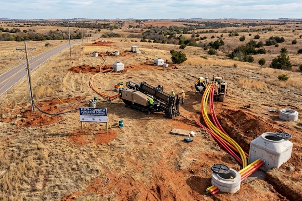
River, highway, and railroad crossings in Deming are where trenchless is default — NMDOT District 1 relocations on I-10 and US-180, BNSF spurs, and Mimbres irrigation structures rarely justify open cut against engineered bore plans.
Directional boring at crossing scale means larger spreads, staged reaming, and agency calendars starting months before drill day. Night MOT and irrigation environmental windows set the schedule.
Municipal trunks, telecom backbones, and electric feeders share corridor headaches — multiple utilities in one casing need engineered dividers, not ad hoc bundling.
Real Luna County angles — not generic statewide copy.
NMDOT MOT and night windows — permit lead exceeds bore duration.
Ditch easement and bank stability — HDD avoids open cut through district infrastructure.
Railroad template, flagging, and inspection — HDD or jack per agreement.
NMDOT permits — long shot with staged ream and survey closeout.
Deming crossing work starts with engineered profile and controlling permit — NMDOT, railroad, or irrigation authority leads beyond standard 811. Larger rigs with mud plants and pullback monitoring; as-built survey before restoration.
Luna County desert floors carry sandy loam, caliche hardpan, and rocky cobble fill — Mimbres valley alluvium and I-10 grading debris change mud programs mile to mile.
Deming bores encounter sandy loam and caliche hardpan on flat desert parcels with rocky cobble lenses near Florida Mountains approach roads. Mimbres River valley fringe carries alluvium with higher groundwater after monsoon storms — buoyancy management matters on longer HDPE pulls. I-10 interchange grading can hide debris that potholing catches before pits are sized. We do not assume Las Cruces valley sand models apply on open Chihuahuan Desert fill.
Chihuahuan Desert heat, spring wind, and summer monsoons drive Deming bore schedules — Mimbres River runoff and irrigation-season groundwater shifts are built into quotes.
Summer heat above 100°F affects crew safety and fluid performance on exposed I-10 pads. Monsoon cloudbursts fill Mimbres arroyos and soften desert ROW from July through September — entry pit work may wait for dry windows. Spring wind complicates cage handling on open highway sites. Irrigation season raises shallow groundwater on agricultural-adjacent bores — we schedule around known saturation patterns.
City of Deming Community Development, Luna County ROW, NMDOT District 1 on I-10 and US-180, irrigation district easements, and El Paso Electric agreements apply on many alignments.
City of Deming Community Development governs street cuts, driveway removals, and drainage work along municipal ROW. Luna County rules apply on unincorporated parcels toward Columbus and the agricultural fringe. NMDOT District 1 controls I-10, US-180, and state highway bores — MOT plans are common on Gold Street frontage. Irrigation district easements along Mimbres laterals add coordination beyond standard 811. El Paso Electric agreements govern electric-adjacent paths in southern New Mexico.
Major crossings rarely justify open cut — detour and ditch easement impact favor trenchless once alignment is approved.
Length, diameter, groundwater, environmental windows, flagging, engineering, inspection.
You share plans or describe the problem; we confirm alignment, depth, access, and which trenchless method fits New Mexico soils.
New Mexico 811 ticket filed; two business days minimum before pits open unless your permit path differs. We pothole where marks conflict.
Bore plan, NMDOT or city ROW permits, railroad agreements, and crossing engineering when the path leaves private property.
Compact spread for tight Santa Fe lots; larger HDD for I-25 or I-40 relocations — matched to length and diameter.
Steered pilot on design line, ream passes sized for your pipe or casing, fluid program tuned for caliche or adobe clay.
HDPE fusion, steel casing, or multi-duct bundle pulled with tension and bend-radius monitoring.
Pressure test, mandrel, or survey records for owners, inspectors, and operators as spec requires.
Compact pits, replace gravel or hardscape per scope, leave 811 ticket and locate map in your project file.
Weeks-to-months depending on district and scope — permits before drill date.
Possible with engineered dividers per owner spec — not improvised bundling.
Mimbres River corridor, irrigation laterals, and desert flood channels each carry different easement rules.
Yes — BNSF templates with flagging; agreements often set critical path.
Length, diameter, MOT, and inspection drive price — engineered quotes only.
24/7 — Emergency dispatch statewide. Tell us entry, exit, pipe size, and county — a bore specialist calls back with cost drivers, not a flat rate.
Scope your alignment
Step 1 of 2 — path, pipe, and city first