BNSF casing near valley rail spur
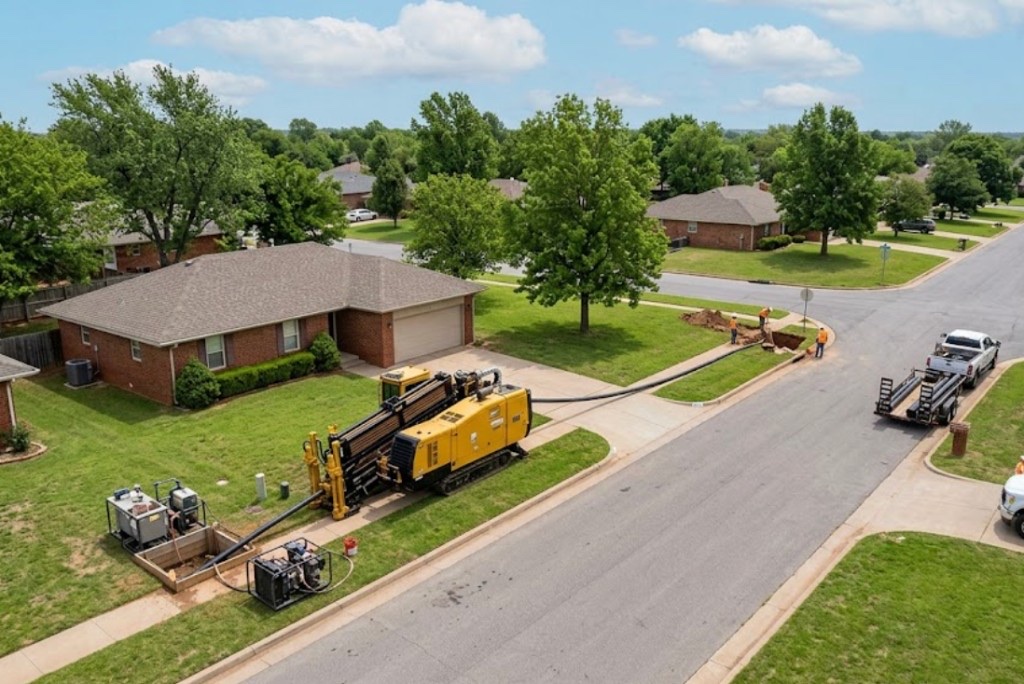
Railroad template with welded inspection and flagging — drive pit dewatering in variable fill near track grade.
Los Lunas, NM · Valencia County
Jack and bore casing on Los Lunas rail spurs and conservancy structures — straight steel pushes when BNSF templates and NMDOT specs require rigid carrier protection.
Auger boring in Los Lunas fits BNSF valley rail agreements, storm outfalls toward bosque drainage, and straight runs under I-25 approach slabs where casing grade matters more than steerable flexibility. Shored pits handle adobe clay sidewalls and sandy bosque fill.
Directional boring in Los Lunas handles curves and long HDPE on residential laterals; jack and bore wins when the engineer specifies welded casing under rail embankment or conservancy levee on a line-and-grade push.
Middle Rio Grande Conservancy District structures and bosque flood-control channels favor cased crossings over open cut through ditch banks — auger bore scopes dewatering and inspection per district detail when applicable.
Real Valencia County angles — not generic statewide copy.
Railroad template with welded inspection and flagging — drive pit dewatering in variable fill near track grade.
Straight RCP push where slope stability blocks open cut — groundwater and conservancy holds scoped upfront.
Short rigid carrier under mixed-use hardscape — grade control on 50-foot push beats HDD tolerance on some municipal details.
NMDOT detail with internal dividers for telecom and electric — jack sets shell before internal pulls.
Los Lunas auger bore layouts pits on survey line after locates and shoring design for clay or sand. Casing advances with rotating head; railroad and conservancy inspections follow controlling agreements. Reception pit exposes face for carrier grout per village or NMDOT detail.
Valencia County bosque fringe carries Rio Grande sand, adobe clay, and caliche hardpan — irrigation ditch proximity and old farmland cobbles change mud programs parcel to parcel.
Los Lunas bores encounter Rio Grande valley sand and adobe clay on bosque-adjacent parcels with caliche hardpan between 2 and 7 feet on mesa-top infill. Old farmland grading can hide cobble lenses and buried irrigation structures that potholing catches before pits are sized. Shallow groundwater along conservancy ditches and the bosque raises buoyancy risk on longer HDPE pulls — we size ream stages accordingly, not with a Permian basin template.
Middle Rio Grande valley heat, spring wind, and monsoon runoff shape Los Lunas bore schedules — bosque groundwater and conservancy ditch saturation are built into quotes.
Monsoon season from July through September softens bosque-adjacent ROW and can delay entry pits on sandy fill. Spring wind affects cage and fluid handling on exposed I-25 pads. Winter cold snaps slow morning startup but rarely stop work — we communicate when dry conditions matter for caliche-heavy pits rather than risk frac-outs toward conservancy ditches.
Village of Los Lunas Community Development, Valencia County ROW, NMDOT District 3 on I-25 and NM-314, Middle Rio Grande Conservancy District easements, and PNM agreements apply on many alignments.
Village of Los Lunas Community Development governs street cuts, driveway removals, and drainage work along municipal ROW. Valencia County rules apply on unincorporated parcels toward the agricultural fringe. NMDOT District 3 controls I-25, NM-314, and state highway bores — MOT plans are common on Main Street frontage. Middle Rio Grande Conservancy District easements along irrigation laterals add coordination beyond standard 811. PNM easement agreements govern electric-adjacent paths.
Jack and bore preserves rail and highway width on straight obstacles. Curved HDPE without casing shifts to HDD. Open cut across BNSF ROW or conservancy banks is rarely approved versus cased template.
Casing size, drive length, pit depth, groundwater, rail or highway flagging, and welding inspection.
You share plans or describe the problem; we confirm alignment, depth, access, and which trenchless method fits New Mexico soils.
New Mexico 811 ticket filed; two business days minimum before pits open unless your permit path differs. We pothole where marks conflict.
Bore plan, NMDOT or city ROW permits, railroad agreements, and crossing engineering when the path leaves private property.
Compact spread for tight Santa Fe lots; larger HDD for I-25 or I-40 relocations — matched to length and diameter.
Steered pilot on design line, ream passes sized for your pipe or casing, fluid program tuned for caliche or adobe clay.
HDPE fusion, steel casing, or multi-duct bundle pulled with tension and bend-radius monitoring.
Pressure test, mandrel, or survey records for owners, inspectors, and operators as spec requires.
Compact pits, replace gravel or hardscape per scope, leave 811 ticket and locate map in your project file.
Casing and straight alignments favor auger bore. Curved paths or long HDPE without casing favor HDD — engineer method note drives the call.
Jacking may finish in days; BNSF agreements and inspection often drive weeks-to-months lead.
Running sand in bosque fill without dewatering can stall progress — test pits help near conservancy structures.
Yes when plans specify casing and straight gravity grade — large trunks may use microtunneling instead.
24/7 — Emergency dispatch statewide. Tell us entry, exit, pipe size, and county — a bore specialist calls back with cost drivers, not a flat rate.
Scope your alignment
Step 1 of 2 — path, pipe, and city first