I-25 trunk relocation near Rio Bravo interchange
NMDOT MOT and night drilling windows — permit lead exceeds bore duration; alignment engineered before bid.
Albuquerque, NM · Bernalillo County
Albuquerque highway, rail, and bosque crossings on I-25, I-40, and the Rio Grande — long-span HDD and casing when open cut fails NMDOT, floodplain, and BNSF review.
River, highway, and railroad crossings in Albuquerque are where trenchless stops being optional — NMDOT District 3 relocations on I-25 and I-40, BNSF spurs through the rail yards, and Rio Grande bosque floodplain paths rarely justify politically or economically against engineered bore plans.
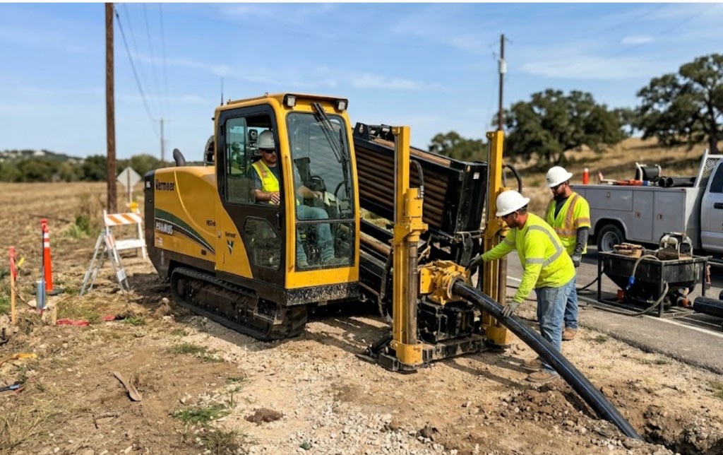
Directional boring in Albuquerque at crossing scale means larger spreads, staged reaming, pullback monitoring, and agency calendars that start months before drill day. Traffic control, night MOT, and environmental windows set the schedule more often than rig availability.
Municipal water and sewer trunks, telecom backbones, and electric feeders share the same corridor headaches — multiple utilities in one casing require engineered dividers and maintenance access, not ad hoc bundling. Directional Boring New Mexico scopes survey as-builts and inspection holds per owner agreement.
Real Bernalillo County angles — not generic statewide copy.
NMDOT MOT and night drilling windows — permit lead exceeds bore duration; alignment engineered before bid.
Floodplain and bank stability review — HDD profile avoids open cut through saturated alluvium and trail systems.
Railroad template, flagging, and welded casing inspection — jack and bore or HDD per agreement.
NMDOT permits and franchise alignment — long shot with staged ream and survey closeout.
Albuquerque crossing work begins with engineered profile and controlling permit identification — NMDOT, railroad, or floodplain authority leads notification beyond standard 811. Larger rigs mobilize with mud plants and pullback monitoring; inspection milestones follow agency and owner documents. As-built survey delivers before final restoration.
Bernalillo County mixes caliche hardpan, adobe clay, and Rio Grande valley sand — foothill volcanic tuff appears on east-side shots toward the Sandias.
Most Albuquerque bores hit caliche crust between 2 and 8 feet, then adobe clay or Rio Grande sand depending on distance from the river. East toward the Sandias, volcanic tuff and fractured basalt slow penetration without the right bit and mud program. Westside infill on old farmland can hide cobbles and debris lenses that stall reaming if geotech is skipped. Shallow groundwater along the bosque raises buoyancy risk on long HDPE pulls — we size ream stages and pullback tension accordingly, not with a generic Permian basin template.
High-desert sun, spring winds, and July–September monsoons shape Albuquerque bore schedules — lightning holds and post-storm arroyo runoff are planned into quotes.
Monsoon season from July through September is Albuquerque's biggest calendar variable. Saturated adobe clay softens ROW and can delay entry pits; arroyo channels carry debris after cloudbursts. Spring winds affect cage and fluid handling on exposed Westside pads. Winter cold snaps at 5,300 feet elevation slow morning startup but rarely stop work — we communicate when dry conditions matter for caliche-heavy pits rather than risk a frac-out toward the bosque.
City of Albuquerque Planning & Development, Bernalillo County ROW, NMDOT District 3, Rio Grande floodplain, and BNSF rail agreements apply on many alignments.
Inside Albuquerque city limits, street cuts, driveway removals, and bosque-adjacent work may need Planning & Development permits. Bernalillo County ROW rules apply on unincorporated pockets toward the airport and South Valley. NMDOT District 3 controls I-25, I-40, and Paseo del Norte state bores — expect traffic control plans and sometimes night-only windows. BNSF agreements govern rail-yard-adjacent crossings. Historic districts near Old Town and Downtown may add review on pit placement and surface restoration.
Major Albuquerque crossings rarely justify open cut — detour cost, floodplain impact, and lane closure math favor trenchless once alignment is approved. Short local street bores are a different scope than mile-class highway crossings.
Length, diameter, groundwater, environmental windows, flagging, engineering, inspection.
You share plans or describe the problem; we confirm alignment, depth, access, and which trenchless method fits New Mexico soils.
New Mexico 811 ticket filed; two business days minimum before pits open unless your permit path differs. We pothole where marks conflict.
Bore plan, NMDOT or city ROW permits, railroad agreements, and crossing engineering when the path leaves private property.
Compact spread for tight Santa Fe lots; larger HDD for I-25 or I-40 relocations — matched to length and diameter.
Steered pilot on design line, ream passes sized for your pipe or casing, fluid program tuned for caliche or adobe clay.
HDPE fusion, steel casing, or multi-duct bundle pulled with tension and bend-radius monitoring.
Pressure test, mandrel, or survey records for owners, inspectors, and operators as spec requires.
Compact pits, replace gravel or hardscape per scope, leave 811 ticket and locate map in your project file.
District and scope drive weeks-to-months — assume permits before drill date, not parallel to mobilization.
Possible with engineered dividers and maintenance access per owner spec — not improvised bundling.
Rio Grande, North Diversion Channel, and arroyo tributaries each carry different floodplain and access rules.
Yes — BNSF templates with flagging and inspection; railroad agreements often set the critical path.
Length, diameter, groundwater, MOT, environmental windows, and inspection drive price — engineered quotes only.
24/7 — Emergency dispatch statewide. Tell us entry, exit, pipe size, and county — a bore specialist calls back with cost drivers, not a flat rate.
Scope your alignment
Step 1 of 2 — path, pipe, and city first